Lost History of Ancient Tamils / Tamizhs
In continuation from the previous post - Kumari Kandam - Part1
https://divinediyaas.blogspot.com/2019/12/kumari-kandam-ancient-tamilakam-part-1.html
Early Pandya kings who ruled Kumari kandam was dated back to before the beginning of Satya Yuga (First Yuga in Yuga cycle). How can be Pandyas dated back to Satya yuga ? No books survived to say about it, but there are links of references to confirm the truth that Pandyas from Kumari kandam were the first cultured, rich civilization in the World. It was the land of Devas (Gods) !
Now, little history over here, to prove that Pandyas were the First ruler of Dravida Desa and their land Kumari Kandam was lost.
According to many Hindu holy literatures like Matsya Purana, Vishnu Purana and Kurma Purana, there are seven sacred mountains which covers the ancient India, they are Mahendra, Malaya, Sahaya, Suktimat, Riksha, Vindhya and Paripatra mountains. In Matsya purana and Vishnu Purana, it is mentioned that " Matsya (Fish), the first avatar of Lord Vishnu, appeared as small fish to the Dravidian King Shraddhadeva / Satyavrata (Meaning: Always Truthful), while he was washing his hands in a river, which was flowing down from the Malaya Mountains. He was also known as Vaivasvata, the son of Vivasvana and therefore known as Vivasvata Manu (Current and Seventh Manu)."
The little fish asked the King to save him. So, in order to save the fish, the King has put the fish in a jar of water. But, the fish kept growing bigger and bigger, then the King has put the fish into a big pitch, it turned out to be less for the fish, then he transferred into a well. Well was also insufficient for the ever growing fish, so the King Satyavrata changed the place and put the fish into a huge tank which was about 16 miles height and 8 miles breadth. It was also not sufficient, then changed to river and then finally he placed the magical fish into the ocean, it looked like a huge Dolphin.


So, from Kumari Kandam many kings, chieftains and people migrated towards North. While migrating, due to the change in ocean currents and Tsunamis, some people has moved towards East and some traveled towards West directions.
At the time of deluge, Lord Vishnu appeared as horned fish and AdiShesha (King of Serpents) appeared as rope, with which the King fastened the boat to the horn of the Fish.

With the help of Lord Vishnu's Matsya Avatar and the Serpent, the giant boat with the Pandya King, Chieftains and animals has survived through the flood and it perched on the top of Malaya Mountains. After the deluge, Manu's family and Sapta rishis repopulated the Earth. Sangam literature refers this Malaya Mountain to the present day 'Pothigai Hills' in Tamil Nadu. Many people claim that Malaya is the present day Sacred Himalayas. No, it's not!! Logically, during a drastic flood, people from South land(Kumari Kandam) will try to reach a near by elevated mountain, here it's Pothigai Hills (Also called as 'Agathiyar Malai'), which is 50 kilometers North from Kanya kumari.
So, Himalayas was not referred as mount Malaya in the early texts and also Agasthiyar Malai in western ghats are much older and Sacred than Himalayas.
Scientific Reason for the Deluge in Kumari Kandam:
This flood occurred during first part of Satya Yuga around 9500 BCE. Satya Yuga started around 11,350 BCE (Separate Yuga Cycle post with Detailed Explanation and Reference ). In the last 14,500 years, the ice glaciers were melting rapidly, due to the increase in Earth's temperature. This coincides with the date of last glacier melting period where the Earth faced more warmth. The melting rate of glaciers were high, which caused the waters to flow rapidly to reach oceans. This sudden rise in sea level caused Tsunamis and floods.

Coming back to the post, From Kumari Kandam, Vivasvata Manu reached the Pothigai hills and expanded his kingdom in Southern India. As the Kumari Kandam was lost, he didn't go back to his motherland and continued to rule in Bharata Kandam. He was able to save the life on Earth with the help of Lord Vishnu. So, the King Satyavrata and the Saptarishis propounded the code of laws for the society known as 'MANUSMRITI', it was said to be the text given by first Manu, Son of Brahma (Lord of Creation). Satyavrata / Vaivasvata Manu is the seventh Manu of current Manvantra.
Manu is not a name of a particular person, it is a title given to the person who has been chosen to lead the humanity, Manu is the progenitor of all human races. All human beings are born from Manu's race and therefore called as 'Manavas' (In Tamil, Manithan). Each Manu rules an aeon called 'Manvantra'.
Proof for Satyavrata to a Pandya King of Kumari Kandam ???
There can be many dravidian rulers, how a Pandya king was referred as Vaivasvata Manu / Satyavrata ? The answer revolves around the key 'Malaya' mountain. Malaya mountain is older than Himalayas and it is considered as the one of holiest mount in India. As Maharishi Agastya spent most of his lifetime at this Malaya mountain, it was also called as 'Agasthiar Malai' situated in the Western Ghats of India. Agasthiar Malai / Pothigai Malai is the only place in the World, where there are many distinctive types of flora, fauna and animal species are found that can't be found anywhere else in the World. Very rare types of poisonous Spiders, leeches and snakes can also be found here.

 Agasthiyar Falls
From the verses of Matsya Avatar, it is understood that Satyavrata / Vivasvata Manu was a Dravidian King from South of Bharata (i.e) Kumari Kandam. Saptarishis were part of his Kingdom. In the purana, it was initially mentioned that king washed his hands in the river flowing down from Malaya mountain, which is current Pothigai Hills. Tamrabarani, the ancient sacred river is originated from the Pothigai hills and flowed towards South reaching Kumari Kandam, it glided parallel to the coastal line of Tamil Nadu. (Present day, it's not flowing towards South, it has changed his course to eastern side and reaches Bay of Bengal).
As the king reached Malaya mountain and settled down there till the nature stabilizes, he worshiped and praised the mountain which saved the life on the Earth. He started his empire from the Mountain and to honor the holy hill, he named his son after the mountain as Malayadhwaja Pandiyan, the Second King of Pandyan Dynasty in Vaivasvata Manu (Note: He is not the same one who was mentioned in Mahabharata, This Malayadhwaja Pandyan corresponds to Satya Yuga).
Pandya King changed his Flag symbol to Fish, as a gratitude to Lord Vishnu's Matsya Avatar. The fish symbol of Pandyas are related to Matysa Avatar of Lord Vishnu during the flood, thus it is proving the truth that the early pandya was referred as Satyavrata / Vaivasvata Manu in the Matsya Purana. Also, as Matsya Avatar is the first avatar of Lord Vishnu, it is corresponded to Satya Yuga, which was also coincides with the name of this Pandya King.

This Tamirabarani river, Malaya Mountain, Dravidian King Satyavrata, his son Malayadhwaja Pandya, Pandya's Fish flag, Maharishi Agasthiyar (One of the Sapta Rishis in the Boat) are proving that Kumari Kandam was real and in Kumari Kandam there were no Cholas and Chera kings. Cholas and Cheras were formed only after the submergence of Kapatapuram, the second tamil sangam. So, obviously King Satyavrata was a Pandya King from Kumari Kandam, who headed the human race as Vivasvata Manu from Bharata Kandam.
Pandyas were the First rulers of India, though the symbols of early Pandyas were destroyed in India, it can be seen in other countries. Example, In Sri Lanka , Pandya's twin fish symbol was carved in granite Stone, bas relief from Koneswaram temple at Triconamalea, which carved by later Pandyas.

Kumari Kandam (KK) was land of Devas (Gods), it was before the period of Vedas. Pandya King Satyavrata ruled Kumari Kandam during the reign of Caksusa Manu (6th Manu). At the end of Caksusa Manu, major flood occurred and destroyed his Kingdom. With the help of Lord Vishnu's Matsya Avatar, Satyarata along with Sapta Rishis reached Malaya mountain and he lead the human race as Vaivasvata Manu. This is proving that Pandya king Satyavrata has ruled KK before the beginning of seventh manvatra (present manvantra), before Satya Yuga and period of Vedas.
Kulasekara Pandyan was the first ruler of the Kumari Kandam during that period of Caksusa Manu. Lord Shiva as Soma Sundara Pandyan established First Tamizh Sangam at Thenmadurai of Kumari Kandam. Vivasvata Manu has ruled ancient Kumari Kandam with Bull as their symbol before the deluge, ancient tamizhs considered Bull as symbol as Masculinity and Valor. In Tamil, Pandi / Pandya ('Pandaya') means Early / ancient. This clearly mentions that 'Pandya nadu' means ancient Country.

Pandyan kingdom has 2 different royal symbols: Bull and Twin Fish.
Before the arrival of massive Tsunami, they have started to explore the world, Pandyas traveled across seas, established their kingdom in many countries with their flag Bull / Twin Fish / Single Fish. They have named many places in Tamizh, they were the first explorers of the World. They have majorly built temples for Lord Murugan / Kumaran and Lord Shiva, as they considered Lord Shiva as supreme God and Lord Kumaran as the God of Kumari Kandam.
 Coins of Early Pandyas with Bull symbol (Left Coin) and Twin Symbol Symbol (Right Coin)
They have built many rock cut temples in Tamil Nadu and all over the India, which was later occupied by Jains. Symbols of Pandyas and God statues were demolished, numerous new identical Jain monk statues were inserted and then it was converted into a Jain bed with no traces of early Pandyas.
The main rock cut cave temples of Early Pandyas which are currently present in Tamil Nadu are


At Kalugu Malai, the temple was carved from Rock with Top to Bottom approach (Same methodology was used in Kailasanathar Temple at Ellora Caves - It was also built in Dravidian style with Tall Gopurams, getting any hint ?! )
Pandyas are known for their Rock cut architecture and haven't embarked their symbol in the temples they built, so it was easy for others to claim it as theirs. Many references of early pandyas, their kingdoms, Sangam links , their land, people were painted and carved in the ancient architectures. But, most of them were lost during the continental drifts that caused the Kumari kandam to split from India, Some were sunken under the Ocean, most of the lands were lost and the remaining lands were claimed and demolished by many religions. Today's coastline were once ruled by Pandyas, as they served as their port city, but now one can hardly find any temples in those area. Like wise, all the rock cut caves and temples are converted into Jain beds, this can be easily figured out if one observe the temple's carvings deeply and also in most of the temples at hills, there will be one Dargah near by (Dargah at a Sacred Hindu hill !!!)
Lord Vishnu's Matsya Avatar and King Satyavrata's boat are depicted in various country's stone carvings as Gilgamesh Flood, Noah's Flood theory etc. Ancient Sumerian stone carvings represents Vivasvata Manu's boat with Lord Vishnu in Matsya Avatar. Sumerian civilization is said to be one of the oldest civilization in the world, according to modern archaeologists. Early Pandyas were prior to them, their dates were put forward and suppressed the hidden truths about Tamizhs !!!


Ancient Tamils / Tamizhians traveled towards South East and settled there due to the lost sunken Kumari Kandam. They were the the First one to reach Australia and Antartica.
Pandyas who migrated towards North ,established their second capital at Kapadapuram / Kavadapuram, which was the remaining of Kumari Kandam. In Tamil, Kavattai means a type of pearl, it also means grabbing, as the Oyster grabs. This place was rich in pearls, the pearls of Kapatapuram was world famous, Costly and Unique. Pearls of Pandyas has traveled across the World as masterpiece and this was the busiest and richest port city of Pandyas where they have ruled from 6087 BCE to 1700 BCE.
In Kapadapuram, Second Tamizh Sangam was formed. 'Tolkappiyam', grammar book of Tamizh was published by the author Tolkappiyar in Second Tamizh Sangam. He was a disciple of Sage Agastya, Maharishi Agastya asked Tolkappiyar to write a book as his book 'Agathiyam' didn't survive after the flood. Tolkappiyam belonged to the last phase of second tamizh sangam. Later Kapatapuram was engulfed by Sea around 2000 BCE. Kavadapuram was near to present 'Tiruchendur' in Tamil Nadu. Ancient important sites of Pandyas such as Korkai, Adichanallur were near Kapatapuram. ( Note: Adichanallur is the place dated back to 1800 BCE found with many Dravidian Urns and Burials. Once, it was a major industrial site of Pandyas.)
This Pandya's capital city was also mentioned in Chankya's Arthasastra as 'Pearls from Pandya Kapatam'. Kapatapuram was also mentioned in Ramayana, which corresponds to 'TRETA YUGA'. Kollam in Kerala was served as Port city of Pandyas at West and Kulasekarapatnam at the East. Kulasekarapatnam was named after a Pandya king Kulasekara Pandyan I, who was named in memory of early Kulasekara pandya, the first ruler of Kumari Kandam.
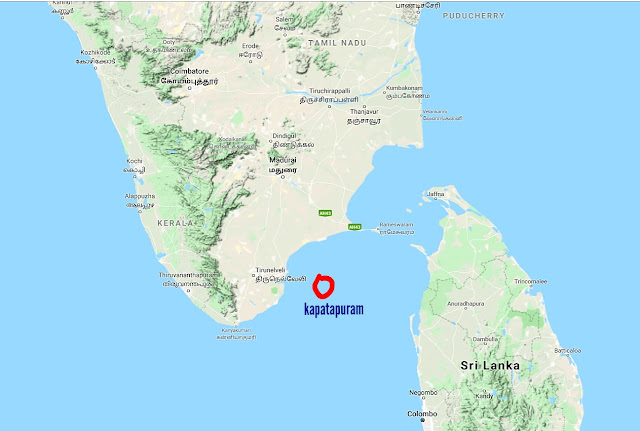
It was also called as Kuadam, the great poet and sage Nakkerar, mentions Kuadam (Kapatapuram) served as second capital of Pandyas from 5800 BCE to 2100 BCE. This was situated at the north of ancient Pahruli river. Later Kapatapuram was also engulfed by Sea, thus the Pandyas has migrated towards North further and established Madurai (at present in Tamil Nadu) as their Capital. Some of the Pandya kings traveled towards North India and Western countries, some has explored towards North East and Eastern directions towards Bangladesh, Indonesia, Malaysia, Singapore, Thailand, Cambodia, Sri Lanka, Australia and Easter Island and they built many temples at mountains. Later many religions have adopted the fish symbol and took credits for the Pandya's works.
Where ever they reached, the love towards their motherland and Tamil wasn't changed and they have marked the symbols of their land in order to revive their roots and identify. Even now, in many places, we can see the symbols of ancient Tamils, many words were taken from Tamizhi / Tamil and adopted in the modern languages. Language spoken by African Tribes, Australian Tribes, Andaman and Nicobar Tribes, Lakshadweep tribes are identical to Tamil.
In continuation from the previous post - Kumari Kandam - Part1
https://divinediyaas.blogspot.com/2019/12/kumari-kandam-ancient-tamilakam-part-1.html
Early Pandya kings who ruled Kumari kandam was dated back to before the beginning of Satya Yuga (First Yuga in Yuga cycle). How can be Pandyas dated back to Satya yuga ? No books survived to say about it, but there are links of references to confirm the truth that Pandyas from Kumari kandam were the first cultured, rich civilization in the World. It was the land of Devas (Gods) !

Now, little history over here, to prove that Pandyas were the First ruler of Dravida Desa and their land Kumari Kandam was lost.
According to many Hindu holy literatures like Matsya Purana, Vishnu Purana and Kurma Purana, there are seven sacred mountains which covers the ancient India, they are Mahendra, Malaya, Sahaya, Suktimat, Riksha, Vindhya and Paripatra mountains. In Matsya purana and Vishnu Purana, it is mentioned that " Matsya (Fish), the first avatar of Lord Vishnu, appeared as small fish to the Dravidian King Shraddhadeva / Satyavrata (Meaning: Always Truthful), while he was washing his hands in a river, which was flowing down from the Malaya Mountains. He was also known as Vaivasvata, the son of Vivasvana and therefore known as Vivasvata Manu (Current and Seventh Manu)."
The little fish asked the King to save him. So, in order to save the fish, the King has put the fish in a jar of water. But, the fish kept growing bigger and bigger, then the King has put the fish into a big pitch, it turned out to be less for the fish, then he transferred into a well. Well was also insufficient for the ever growing fish, so the King Satyavrata changed the place and put the fish into a huge tank which was about 16 miles height and 8 miles breadth. It was also not sufficient, then changed to river and then finally he placed the magical fish into the ocean, it looked like a huge Dolphin.
Matsya Avatar of Lord Vishnu, revealed himself to the King Satyavrata and forewarned him about the massive flood. So, the King has a built a giant boat, which housed his family, Saptarishis, Nine types of Seeds and Animals and sacred books. He also asked his people to migrate towards North side (Bharata Kandam), before the attack of subsequent Tsunamis.

At the time of deluge, Lord Vishnu appeared as horned fish and AdiShesha (King of Serpents) appeared as rope, with which the King fastened the boat to the horn of the Fish.

With the help of Lord Vishnu's Matsya Avatar and the Serpent, the giant boat with the Pandya King, Chieftains and animals has survived through the flood and it perched on the top of Malaya Mountains. After the deluge, Manu's family and Sapta rishis repopulated the Earth. Sangam literature refers this Malaya Mountain to the present day 'Pothigai Hills' in Tamil Nadu. Many people claim that Malaya is the present day Sacred Himalayas. No, it's not!! Logically, during a drastic flood, people from South land(Kumari Kandam) will try to reach a near by elevated mountain, here it's Pothigai Hills (Also called as 'Agathiyar Malai'), which is 50 kilometers North from Kanya kumari.
So, Himalayas was not referred as mount Malaya in the early texts and also Agasthiyar Malai in western ghats are much older and Sacred than Himalayas.
Scientific Reason for the Deluge in Kumari Kandam:
This flood occurred during first part of Satya Yuga around 9500 BCE. Satya Yuga started around 11,350 BCE (Separate Yuga Cycle post with Detailed Explanation and Reference ). In the last 14,500 years, the ice glaciers were melting rapidly, due to the increase in Earth's temperature. This coincides with the date of last glacier melting period where the Earth faced more warmth. The melting rate of glaciers were high, which caused the waters to flow rapidly to reach oceans. This sudden rise in sea level caused Tsunamis and floods.

Coming back to the post, From Kumari Kandam, Vivasvata Manu reached the Pothigai hills and expanded his kingdom in Southern India. As the Kumari Kandam was lost, he didn't go back to his motherland and continued to rule in Bharata Kandam. He was able to save the life on Earth with the help of Lord Vishnu. So, the King Satyavrata and the Saptarishis propounded the code of laws for the society known as 'MANUSMRITI', it was said to be the text given by first Manu, Son of Brahma (Lord of Creation). Satyavrata / Vaivasvata Manu is the seventh Manu of current Manvantra.
Manu is not a name of a particular person, it is a title given to the person who has been chosen to lead the humanity, Manu is the progenitor of all human races. All human beings are born from Manu's race and therefore called as 'Manavas' (In Tamil, Manithan). Each Manu rules an aeon called 'Manvantra'.
Proof for Satyavrata to a Pandya King of Kumari Kandam ???
There can be many dravidian rulers, how a Pandya king was referred as Vaivasvata Manu / Satyavrata ? The answer revolves around the key 'Malaya' mountain. Malaya mountain is older than Himalayas and it is considered as the one of holiest mount in India. As Maharishi Agastya spent most of his lifetime at this Malaya mountain, it was also called as 'Agasthiar Malai' situated in the Western Ghats of India. Agasthiar Malai / Pothigai Malai is the only place in the World, where there are many distinctive types of flora, fauna and animal species are found that can't be found anywhere else in the World. Very rare types of poisonous Spiders, leeches and snakes can also be found here.

Agasthiyar Malai / Pothigai Malai

From the verses of Matsya Avatar, it is understood that Satyavrata / Vivasvata Manu was a Dravidian King from South of Bharata (i.e) Kumari Kandam. Saptarishis were part of his Kingdom. In the purana, it was initially mentioned that king washed his hands in the river flowing down from Malaya mountain, which is current Pothigai Hills. Tamrabarani, the ancient sacred river is originated from the Pothigai hills and flowed towards South reaching Kumari Kandam, it glided parallel to the coastal line of Tamil Nadu. (Present day, it's not flowing towards South, it has changed his course to eastern side and reaches Bay of Bengal).
As the king reached Malaya mountain and settled down there till the nature stabilizes, he worshiped and praised the mountain which saved the life on the Earth. He started his empire from the Mountain and to honor the holy hill, he named his son after the mountain as Malayadhwaja Pandiyan, the Second King of Pandyan Dynasty in Vaivasvata Manu (Note: He is not the same one who was mentioned in Mahabharata, This Malayadhwaja Pandyan corresponds to Satya Yuga).

Pandyas were the First rulers of India, though the symbols of early Pandyas were destroyed in India, it can be seen in other countries. Example, In Sri Lanka , Pandya's twin fish symbol was carved in granite Stone, bas relief from Koneswaram temple at Triconamalea, which carved by later Pandyas.

Kumari Kandam (KK) was land of Devas (Gods), it was before the period of Vedas. Pandya King Satyavrata ruled Kumari Kandam during the reign of Caksusa Manu (6th Manu). At the end of Caksusa Manu, major flood occurred and destroyed his Kingdom. With the help of Lord Vishnu's Matsya Avatar, Satyarata along with Sapta Rishis reached Malaya mountain and he lead the human race as Vaivasvata Manu. This is proving that Pandya king Satyavrata has ruled KK before the beginning of seventh manvatra (present manvantra), before Satya Yuga and period of Vedas.
Kulasekara Pandyan was the first ruler of the Kumari Kandam during that period of Caksusa Manu. Lord Shiva as Soma Sundara Pandyan established First Tamizh Sangam at Thenmadurai of Kumari Kandam. Vivasvata Manu has ruled ancient Kumari Kandam with Bull as their symbol before the deluge, ancient tamizhs considered Bull as symbol as Masculinity and Valor. In Tamil, Pandi / Pandya ('Pandaya') means Early / ancient. This clearly mentions that 'Pandya nadu' means ancient Country.

Pandyan kingdom has 2 different royal symbols: Bull and Twin Fish.
Before the arrival of massive Tsunami, they have started to explore the world, Pandyas traveled across seas, established their kingdom in many countries with their flag Bull / Twin Fish / Single Fish. They have named many places in Tamizh, they were the first explorers of the World. They have majorly built temples for Lord Murugan / Kumaran and Lord Shiva, as they considered Lord Shiva as supreme God and Lord Kumaran as the God of Kumari Kandam.

They have built many rock cut temples in Tamil Nadu and all over the India, which was later occupied by Jains. Symbols of Pandyas and God statues were demolished, numerous new identical Jain monk statues were inserted and then it was converted into a Jain bed with no traces of early Pandyas.
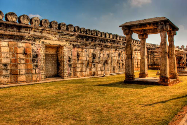
The main rock cut cave temples of Early Pandyas which are currently present in Tamil Nadu are
- Thiruparankundram
- Yoganarasimha Temple, Anaimalai
- Kalugu malai
- Tirumalaipuram
- Malayadikkurichi


Kalugu Malai temple
At Kalugu Malai, the temple was carved from Rock with Top to Bottom approach (Same methodology was used in Kailasanathar Temple at Ellora Caves - It was also built in Dravidian style with Tall Gopurams, getting any hint ?! )
Pandyas are known for their Rock cut architecture and haven't embarked their symbol in the temples they built, so it was easy for others to claim it as theirs. Many references of early pandyas, their kingdoms, Sangam links , their land, people were painted and carved in the ancient architectures. But, most of them were lost during the continental drifts that caused the Kumari kandam to split from India, Some were sunken under the Ocean, most of the lands were lost and the remaining lands were claimed and demolished by many religions. Today's coastline were once ruled by Pandyas, as they served as their port city, but now one can hardly find any temples in those area. Like wise, all the rock cut caves and temples are converted into Jain beds, this can be easily figured out if one observe the temple's carvings deeply and also in most of the temples at hills, there will be one Dargah near by (Dargah at a Sacred Hindu hill !!!)
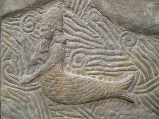
Lord Vishnu's Matsya Avatar and King Satyavrata's boat are depicted in various country's stone carvings as Gilgamesh Flood, Noah's Flood theory etc. Ancient Sumerian stone carvings represents Vivasvata Manu's boat with Lord Vishnu in Matsya Avatar. Sumerian civilization is said to be one of the oldest civilization in the world, according to modern archaeologists. Early Pandyas were prior to them, their dates were put forward and suppressed the hidden truths about Tamizhs !!!

Sumerian Tablet

Babylonian Great Flood

Pandyas who migrated towards North ,established their second capital at Kapadapuram / Kavadapuram, which was the remaining of Kumari Kandam. In Tamil, Kavattai means a type of pearl, it also means grabbing, as the Oyster grabs. This place was rich in pearls, the pearls of Kapatapuram was world famous, Costly and Unique. Pearls of Pandyas has traveled across the World as masterpiece and this was the busiest and richest port city of Pandyas where they have ruled from 6087 BCE to 1700 BCE.
In Kapadapuram, Second Tamizh Sangam was formed. 'Tolkappiyam', grammar book of Tamizh was published by the author Tolkappiyar in Second Tamizh Sangam. He was a disciple of Sage Agastya, Maharishi Agastya asked Tolkappiyar to write a book as his book 'Agathiyam' didn't survive after the flood. Tolkappiyam belonged to the last phase of second tamizh sangam. Later Kapatapuram was engulfed by Sea around 2000 BCE. Kavadapuram was near to present 'Tiruchendur' in Tamil Nadu. Ancient important sites of Pandyas such as Korkai, Adichanallur were near Kapatapuram. ( Note: Adichanallur is the place dated back to 1800 BCE found with many Dravidian Urns and Burials. Once, it was a major industrial site of Pandyas.)
This Pandya's capital city was also mentioned in Chankya's Arthasastra as 'Pearls from Pandya Kapatam'. Kapatapuram was also mentioned in Ramayana, which corresponds to 'TRETA YUGA'. Kollam in Kerala was served as Port city of Pandyas at West and Kulasekarapatnam at the East. Kulasekarapatnam was named after a Pandya king Kulasekara Pandyan I, who was named in memory of early Kulasekara pandya, the first ruler of Kumari Kandam.
It was also called as Kuadam, the great poet and sage Nakkerar, mentions Kuadam (Kapatapuram) served as second capital of Pandyas from 5800 BCE to 2100 BCE. This was situated at the north of ancient Pahruli river. Later Kapatapuram was also engulfed by Sea, thus the Pandyas has migrated towards North further and established Madurai (at present in Tamil Nadu) as their Capital. Some of the Pandya kings traveled towards North India and Western countries, some has explored towards North East and Eastern directions towards Bangladesh, Indonesia, Malaysia, Singapore, Thailand, Cambodia, Sri Lanka, Australia and Easter Island and they built many temples at mountains. Later many religions have adopted the fish symbol and took credits for the Pandya's works.
Where ever they reached, the love towards their motherland and Tamil wasn't changed and they have marked the symbols of their land in order to revive their roots and identify. Even now, in many places, we can see the symbols of ancient Tamils, many words were taken from Tamizhi / Tamil and adopted in the modern languages. Language spoken by African Tribes, Australian Tribes, Andaman and Nicobar Tribes, Lakshadweep tribes are identical to Tamil.
--- Much more truths to unravel in Part 3
- Aarthi Thiyagarajan


